I didn't know about the '
Sea of O'SR' project when I wrote the first of my 'Fortunate Isles' posts and invited other people to contribute - if I had known, I'd probably have just added my input to the Sea of O'SR. The basic motivation (though not necessarily the execution) seems very similar. It's a shame that the Sea of O'SR didn't attract more entries - I think it was a great idea! I now want to play a whole Legend of Zelda: Windwaker/Odyssey-style campaign where the PCs visit loads of islands.
 |
| A particularly lovely version of the Zelda: Wind Waker map from https://www.behance.net/gallery/17865223/Legend-of-Zelda-Wind-Waker-Great-Sea-Map |
 |
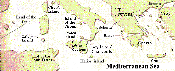
| Odyssey map from here: http://www.irasov.com/odyssey_map.htm |
A big chunk of the mythology and history of my version of Mystara is derived from Greek myth. Several analogues of Greek gods exist in the Thyatian-Minrothad-Karameikos area. A giant minotaur lived in a maze under the city of Minrothad, until it was slain by the Duke of Kerendas, who resembles Theseus in many ways (and I'm considering calling minotaurs 'minrotaurs' in this campaign); a young nobleman exiled from Tel Akbir has sailed to the ends of the
earth to bring back a powerful healing artefact from a distant
city-state; the Emperor of Thyatis is on the point of declaring war on Ierendi, using as an excuse the fact that the son of the King of Ierendi has kidnapped the wife of his brother, the Duke of Biazzan (she went willingly, the real cause of the war is the campaign of piracy that Ierendi has been unofficially conducting on Thyatian and Minrothadi shipping - and I'm sure, at the end of the war, a clever Duke from an insignificant Thyatian island will find it very hard to get home).
In short, in my campaign-world, the northern part of the Sea of Dread and the sea to the east of Thyatis, Ylaruam and the northern kingdoms are the Mediterranean and Black Sea - only they run the other way round: Greece is in the south-east, but the lands of the 'west' (Gorgons/Medusae, Sirens and Circe) are north-east, and those of the 'east' (Troy, Colchis, Persia) are to the west. Clear? Probably not...
Maybe I need to do a map like Ptolemy's
 |
| Ptolemy's map from here http://www.mappery.com/map-of/ptolemy-world-map |
or even the the reconstruction of Herodotus's world-view - only it would be the world as seen from the Imperial capital. Or is that what the Mystara map is? Accurate for Thyatis, Ylaruam and the immediate islands, more and more speculative as we get further from the Imperial City? That could be fun, if when they get to the northlands the players find they look like northern Harn or the map from the Thomas Covenant books...


No comments:
Post a Comment